Geronimo and Alligator Creeks
2024 Geronimo and Alligator Creeks Cleanup
Saturday, April 20, from 9 a.m. to 12 p.m.
Two meeting locations to choose from:
- Seguin ISD-Irma Lewis Outdoor Learning Center
(1865 E US Highway 90, Seguin)
- Oak Creek Elementary School (3060 Goodwin Ln., New Braunfels)
Free Breakfast & Coffee
Online Registration
Flier 
Location
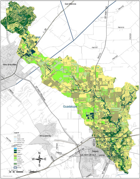
Geronimo Creek and its tributary Alligator Creek are located in Comal and Guadalupe Counties, and lie within the larger Guadalupe River Basin. The headwaters of Alligator Creek begin in southeastern Comal County, just above Interstate 35 near New Braunfels. Alligator Creek flows southeast towards Seguin until about midway in the watershed where it joins Geronimo Creek. The majority of the Alligator Creek watershed lies within the extra-territorial jurisdiction (ETJ) of New Braunfels, while the majority of the Geronimo Creek watershed is almost entirely within the ETJ of Seguin.
Water Quality
Geronimo Creek is monitored by the Guadalupe-Blanco River Authority (GBRA) as part of the Clean Rivers Program. Geronimo Creek is listed on the Texas 303(d) List with a concern for nitrate-nitrogen and an impairment of the contact recreation use, due to elevated E.coli bacteria concentrations.
Public Response to Impaired Water Quality
Starting in 2009, development of the Geronimo and Alligator Creeks Watershed Protection Plan (WPP) was initiated by local stakeholders with the primary goal being to restore and protect water quality and designated uses of the creeks through voluntary, non-regulatory water resource management. Shortly after development of the WPP was completed, it was accepted by EPA on September 13, 2012.
How You Can Be Involved
Public participation is critical throughout implementation, as ultimate success of any WPP depends on stewardship of the land and water resources by landowners, businesses, elected officials, and residents of the watershed. The Geronimo and Alligator Creeks WPP defines strategies and identifies opportunities for stakeholders across the watershed to work together and as individuals to implement voluntary practices and programs that will restore and protect water quality.
You can become an active member of the Partnership by participating in meetings, signing up for email updates, and becoming involved in implementation of the WPP, as well as telling others about this important project! Simply contact Annalee Epps under the Contact Us tab.
Geronimo Creek Watershed & Land Use Map (Download as PDF)
|